India population
The vector map of India population showcases the country’s diverse geography, located in South Asia, bordered by Pakistan, China, Nepal, Bhutan, Bangladesh, and Myanmar. Covering coordinates from approximately 8.4° N to 37.6° N latitude and 68.7° E to 97.2° E longitude, it highlights key points such as major cities like New Delhi and Mumbai, along with significant rivers like the Ganges and Indus, offering invaluable insights into population distribution across the region.
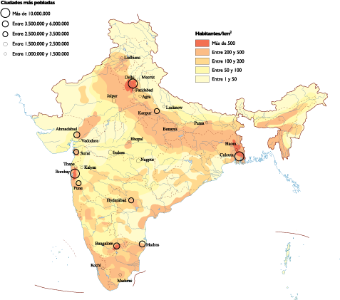
Available in versatile formats like digital vector EPS and AI Illustrator, this map comes with fully editable layers, allowing users to customize data visualization as needed. Whether for academic research or business planning, the flexible designs ensure compatibility across various platforms and projects, making it an essential tool for graphic designers and researchers.
Upon purchase, customers enjoy instant access to the vector map via WeTransfer and email, streamlining the download process. This efficient delivery method ensures that users can begin their projects without delay, enhancing productivity and providing them with the critical demographic insights they need.
Clients benefit from full reproduction rights, allowing unlimited use of the map for commercial or personal projects. Trusted by customers in over 140 countries, the vector map of India population has become a