Rwanda transportation
Rwanda, located in East Africa, is bordered by Uganda, Tanzania, Burundi, and the Democratic Republic of the Congo. Known for its stunning landscapes, the country features key transportation hubs such as its capital, Kigali, and vital routes along Lake Kivu. The geographical coordinates of Rwanda are approximately 1.9403° S latitude and 29.8739° E longitude, making it a crucial link between various regional transport networks.
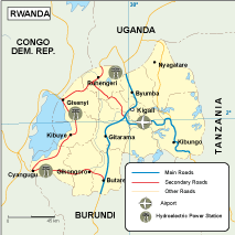
Our vector map of Rwanda transportation is available in versatile digital formats, including EPS and AI Illustrator. Each layer in the map is fully editable, allowing users to customize details suitable for any project or presentation. This flexibility makes it an ideal tool for urban planners, cartographers, and businesses seeking insight into Rwanda's transport infrastructure.
Receiving your vector map has never been easier. With instant download options via WeTransfer and email, you can access your map within moments, ensuring that your planning and research proceed without delay. This convenient delivery system allows professionals from all fields to integrate essential transportation data efficiently.
Clients across over 140 countries trust our services, as each purchase comes with full reproduction rights. This means you can utilize the Rwanda transportation vector map in multiple projects without concern for copyright restrictions. This user-friendly and comprehensive resource supports