Sierra leone climate
Sierra Leone is situated on the west coast of Africa, bordered by the Atlantic Ocean to the southwest, Guinea to the northeast, and Liberia to the southeast. The country's coordinates are approximately 8.5° N latitude and 11.5° W longitude. Key locations include the capital city, Freetown, known for its vibrant culture and historic significance, as well as major rivers like the Sierra Leone River that flows towards Freetown and forms a crucial part of the landscape.
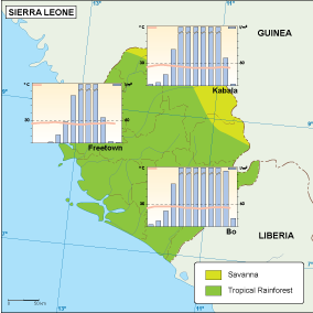
The vector map of Sierra Leone's climate is available in multiple formats, including digital vector EPS and AI Illustrator. These formats ensure flexibility, allowing users to easily manipulate the fully editable layers to suit their specific needs. Whether for educational purposes or professional projects, this map can be customized with precision.
Conveniently, the Sierra Leone climate vector map can be instantly downloaded via WeTransfer or sent directly to your email. This efficient delivery method ensures you receive the high-quality map promptly, enabling you to begin your projects without delay.
When you purchase the vector map of Sierra Leone's climate, you receive full reproduction rights, allowing you to use the map for commercial and personal projects. Our clients span over 140 countries, reflecting the global demand for quality mapping solutions. Enjoy