Austria land use
Austria, located in Central Europe, is bordered by eight countries, including Germany and Italy. This beautiful landlocked nation is known for its stunning geography, which includes the majestic Alps and significant rivers like the Danube. Key cities such as Vienna and Salzburg add to its charm, making Austria a focal point for cultural and geographical exploration.
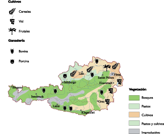
Our vector map of Austria land use is available in versatile digital formats, including EPS and AI Illustrator. Each layer is fully editable, allowing you to customize the map to suit your specific project needs. This flexibility makes it an invaluable tool for designers and planners wanting to visualize land use effectively.
For your convenience, the map can be instantly downloaded via WeTransfer or sent directly to your email. This quick delivery ensures that you can start using the vector map of Austria land use without any delays.
When you purchase our vector map, you receive full reproduction rights, empowering you to use the map in various applications. With clients in over 140 countries, our maps are trusted for their reliability and versatility in design and analysis.