Burundi transportation 2025-12-08 06:00:21
Burundi, located in East Africa at coordinates 3.3732° S, 29.9189° E, is a landlocked country bordered by Rwanda, Tanzania, and Lake Tanganyika. The vector map of Burundi transportation showcases essential routes, cities like Gitega and Bujumbura, major rivers such as the Ruzizi and the tributaries that feed into the lake, making it an invaluable resource for navigation and planning.
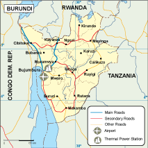
Available in versatile digital vector formats such as EPS and AI Illustrator, this map features fully editable layers that allow users to customize it according to their specific needs. Whether for educational, governmental, or personal use, it empowers designers and planners with the flexibility they require.
Upon purchase, the vector map can be instantly downloaded via WeTransfer and delivered directly to your email, ensuring quick access to this essential resource without any hassle.
With full reproduction rights included, clients in over 140 countries can utilize the vector map of Burundi transportation for various purposes, from commercial projects to educational presentations, enhancing global reach and effectiveness.