Belgium economic
Belgium, located in Western Europe, is bordered by France, Germany, Luxembourg, and the Netherlands. The key cities include Brussels, the capital, as well as Antwerp, Ghent, and Bruges, while significant rivers like the Meuse and Scheldt enhance its geography. With coordinates approximately 50.8503° N latitude and 4.3517° E longitude, this strategic location plays a crucial role in European trade and economy, making the vector map of Belgium economic invaluable for various industries.
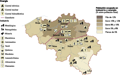
Our Belgium economic vector map is available in multiple digital formats, including EPS and AI Illustrator. Each file features fully editable layers, allowing you to customize and manipulate the map according to your specific needs, whether it’s for presentations, reports, or educational purposes.
Upon purchase, enjoy the convenience of instant delivery via WeTransfer and email, ensuring that you can access your Belgium economic vector map immediately. This streamlined process means you can get started on your projects without delay.
With full reproduction rights included, our vector maps are perfect for clients in over 140 countries. Whether you're a designer, educator, or business professional, our Belgium economic vector map provides the flexibility and rights you need to use it effectively in your work.