Belgium population
Belgium, located in Western Europe, is bordered by France, Germany, Luxembourg, and the Netherlands. Its geographical coordinates are approximately 50°N latitude and 4°E longitude. The country is renowned for its vibrant cities such as Brussels, Antwerp, and Ghent, along with significant waterways like the River Meuse and the Scheldt. These key points make a vector map of Belgium's population essential for understanding demographic distribution.
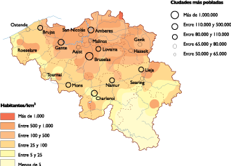
The vector map of Belgium's population is available in versatile formats, including digital EPS and AI Illustrator files. With fully editable layers, users can customize the map according to their specific needs, making it an invaluable tool for researchers, urban planners, and educators.
With our service, you can enjoy instant delivery via WeTransfer and email, ensuring you have quick access to your vector map. This streamlined process allows you to commence your project without delay, making it convenient for busy professionals.
Clients from over 140 countries benefit from full reproduction rights with our vector map of Belgium's population. This extensive licensing allows for unlimited use in various applications, whether for commercial purposes or educational resources, empowering users to leverage the data effectively.