Burundi transportation
Burundi, located in East Africa, is bordered by Tanzania to the east, Lake Tanganyika to the west, and Rwanda to the north. The country’s coordinates are approximately 3.3731° S latitude and 29.9189° E longitude, with key cities including Gitega, Bujumbura, and the Ruzizi River, which flow towards the national borders, playing a crucial role in transportation. The vector map of Burundi’s transportation system provides comprehensive insights into the road networks, railways, and vital waterways that shape the region's connectivity.
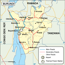
Our vector maps are available in digital formats, including EPS and Adobe Illustrator (AI), allowing for fully editable layers. This flexibility means you can customize the map to fit your specific needs, enhancing your projects with detailed and accurate transportation layouts. Perfect for professional presentations or academic projects, the vector map of Burundi’s transportation system ensures high quality and adaptability.
Upon placing an order, you will receive instant delivery of the vector map via WeTransfer and email, making it easy to access your files immediately. This seamless delivery system guarantees that you can start working on your project without delay, ensuring efficiency and convenience at your fingertips.
With full reproduction rights included, you can use the vector map of