Equatorial guinea vegetation 2025-12-08 18:00:10
The vector map of Equatorial Guinea's vegetation showcases the rich biodiversity of this Central African nation, located between the latitudes of 1°N and 3°N. Bordered by Cameroon to the north and Gabon to the south and east, it features key geographical elements including the capital city, Malabo, situated on Bioko Island, and the notable Río Muni on the mainland. This map provides detailed insights into the country's ecosystems, enhancing understanding of its unique flora.
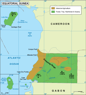
Available in digital vector formats such as EPS and AI Illustrator, this editable map presents fully customizable layers. Users can effortlessly adjust the visual elements to suit their specific needs, making it ideal for professionals in environmental studies, cartography, or design. The flexibility of these formats enhances usability across various projects.
Once purchased, the vector map of Equatorial Guinea's vegetation is delivered instantly via WeTransfer and email, ensuring you receive your high-quality resource without delay. This quick access allows you to dive right into your work, streamlining your project development process while saving valuable time.
With full reproduction rights included, clients can confidently use the vector map across diverse applications. Trusted by customers in over 140 countries, this product meets the needs of researchers, educators, and