Guinea transportation
Guinea, located in West Africa, is bordered by the Atlantic Ocean to the west and shares borders with several countries, including Senegal, Mali, and Côte d'Ivoire. Its geographical coordinates are approximately 10°N latitude and 10°W longitude. The country features significant transportation routes connecting its capital, Conakry, to major rivers like the Niger and coastal ports, facilitating trade and movement throughout the region.
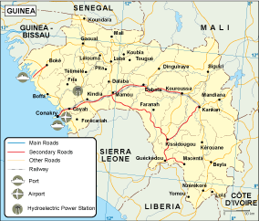
Our vector map of Guinea transportation is available in versatile formats, including digital vector EPS and AI Illustrator files. Each layer is fully editable, making it easy for users to customize and enhance their transportation planning or geographic studies.
Upon purchase, you can enjoy swift access to your vector map via instant download through WeTransfer or email, ensuring you have the resources you need without delay.
With full reproduction rights included, our vector maps are ideal for clients worldwide, supporting users from over 140 countries in their projects and presentations related to transportation in Guinea.