Guinea vegetation
The vector map of Guinea vegetation offers a detailed depiction of this West African country, located along the Atlantic Ocean at coordinates approximately 10.0° N latitude and 10.0° W longitude. Key geographical features include the capital city of Conakry, the Niger River to the east, and lush areas bordering neighboring countries like Sierra Leone and Liberia. This vibrant map serves as a valuable resource for environmental studies and planning.
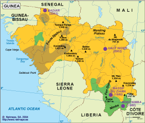
Available in versatile digital formats such as EPS and AI Illustrator, this vector map of Guinea vegetation includes fully editable layers, allowing users to customize elements to suit their specific needs. Whether for professional projects or educational purposes, the map caters to various applications by providing scalable graphics without loss of quality.
Upon purchase, clients receive hassle-free delivery through instant download via WeTransfer and email, making it easy to access the vector map of Guinea vegetation promptly. This efficient delivery process ensures that users can begin working with their new assets without delay.
Clients enjoy full reproduction rights with their purchase, allowing them to use the vector map across a wide range of applications. Serving an international clientele in over 140 countries, this resource effectively supports diverse projects, from academic research to geographic analyses, empowering users to engage with Guinea’s unique vegetation landscapes.