Ivory coast
The vector map of Ivory Coast presents a detailed geographical representation of this West African nation, located between Ghana to the west and Burkina Faso to the north. With coordinates approximately 7°N latitude and 5°W longitude, the map highlights key cities like Abidjan, the nation's economic hub, and major rivers such as the Bandama. These features, along with its borders with neighboring countries, create an informative resource for understanding the region's geography.
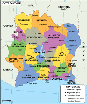
Available in popular digital formats such as EPS and AI Illustrator, the vector map of Ivory Coast boasts fully editable layers, allowing for seamless customization. Whether you’re creating educational materials or engaging visual content, the map's versatility enhances design projects while ensuring clarity.
Upon purchase, clients can enjoy instant delivery through secure methods like WeTransfer and email. This ensures you can integrate the vector map into your projects without delay, facilitating quick access to valuable resources.
With full reproduction rights included, clients in over 140 countries benefit from this high-quality map, empowering global users to create and share their projects confidently. Whether for commercial use or educational purposes, the vector map of Ivory Coast is an indispensable tool in your design arsenal.