Malawi transportation
Malawi, located in southeastern Africa, is bordered by Zambia to the west, Tanzania to the north, and Mozambique to the south and east. This landlocked country features remarkable landscapes, including Lake Malawi, which stretches along its eastern border. The key transportation hubs include the capital city, Lilongwe, and the bustling commercial center, Blantyre. Vector maps of Malawi transportation highlight essential routes, rivers, and borders, essential for effective navigation and planning.
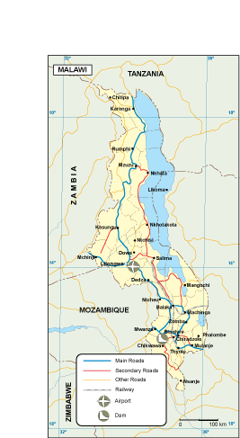
Our vector maps of Malawi transportation come in various formats, including digital vector EPS and AI Illustrator files. Each map features fully editable layers, allowing for complete customization to suit specific project needs. Whether you’re planning a report, presentation, or analysis, these maps make it easy to visualize transportation networks throughout Malawi.
Delivery of your vector map is simple and efficient, with instant downloads available via WeTransfer and email. This ensures you can access your high-quality map of Malawi transportation quickly, enabling immediate use in your projects or presentations.
By purchasing our vector maps, you acquire full reproduction rights, allowing you to use and modify the content freely. We serve clients in over 140 countries, ensuring that professionals around the globe can access our comprehensive collection of editable maps, including vital transportation routes in Malawi.