Liberia economic
Explore the vector map of Liberia, showcasing its unique economic landscape. Situated on the West African coast, Liberia is bordered by Sierra Leone, Guinea, and Côte d'Ivoire. Key geographic features include the capital city, Monrovia, and major waterways like the Saint Paul River, making this vector map essential for any economic analysis or project.
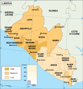
Our vector map of Liberia is available in high-quality digital formats such as EPS and AI Illustrator, ensuring you have fully editable layers for customization. This versatile map allows you to emphasize specific economic data, making it perfect for presentations, reports, or strategic planning.
Enjoy the convenience of instant delivery through WeTransfer and email, ensuring you receive your vector map promptly and securely. Our efficient service ensures you can get started on your project right away without any delays.
With full reproduction rights included, our vector map of Liberia serves clients in over 140 countries. This allows businesses, government agencies, and educators to leverage this valuable resource without restrictions, enhancing their understanding of Liberia's economic framework.