Comores physical
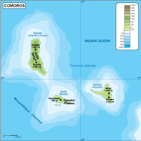
The vector map of Comores physical provides a detailed representation of this archipelago located off the southeastern coast of Africa in the Indian Ocean. Comprising three major islands—Grande Comore, Mohéli, and Anjouan—the map highlights important geographical features such as Mount Koni, the highest point, and the region's extensive coastline. Key cities like Moroni and Moutsamoudou are clearly marked, offering insights into urban development while rivers and borders are distinctly shown for geographic context.
Available in versatile digital formats, including editable EPS and AI Illustrator files, the vector map ensures that users can customize the layers according to their specific needs. This flexibility allows designers and cartographers to manipulate data easily, enhancing the overall usability for various projects.
Upon purchase, customers can enjoy instant delivery via WeTransfer and email, ensuring quick access to the vector map files. This seamless process allows users to start their projects immediately without delay, providing convenience for both personal and professional use.
Clients receive full reproduction rights with their purchase, granting them the freedom to use the vector map of Comores physical across a variety of applications. Trusted by satisfied customers in over 140 countries, this map serves as an essential resource for educational, commercial, and personal endeavors globally.