Hungary population
Hungary, located in Central Europe, boasts a rich geographical tapestry defined by its capital city, Budapest, and major rivers like the Danube and Tisza. This landlocked country shares borders with Austria, Slovakia, Ukraine, Romania, Serbia, Croatia, and Slovenia, presenting a unique blend of cultural influences and regional diversity. The geographic coordinates of Hungary are approximately 47.1625° N latitude and 19.5033° E longitude, making it a strategic location in Europe.
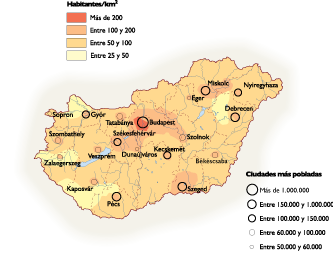
Our vector map of Hungary population is available in versatile digital formats such as EPS and AI Illustrator, ensuring that you can easily modify it for your specific needs. Fully editable layers allow for detailed customization, whether you’re working on a demographic presentation or an educational project focused on Hungary.
With our efficient delivery system, you can instantly download the vector map via WeTransfer or receive it directly through email. This ensures that you can start your project without any delays and seamlessly integrate the map into your workflow.
Clients across more than 140 countries benefit from our vector maps, which come with full reproduction rights. Whether you’re an educator, a researcher, or a business analyst, our Hungary population vector map is a valuable resource for a wide array of applications while maintaining full legal