Burkina faso
Burkina Faso is a landlocked country in West Africa, bordered by Mali to the north, Niger to the east, and Ghana to the south. Its geographic coordinates are approximately 12.2383° N latitude and 1.5616° W longitude. Key points include Ouagadougou, the capital city, and the Comoé River that flows through the region, enhancing its topographical richness. A vector map of Burkina Faso captures these geographical details, making it invaluable for education, planning, and development projects.
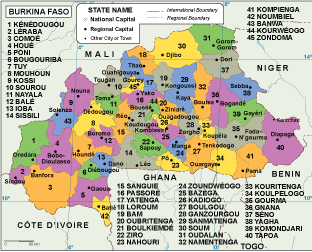
Our vector map of Burkina Faso comes in versatile formats such as digital vector EPS and AI Illustrator. Designed for ease of use, it features fully editable layers that allow you to customize regions, cities, and routes as needed. This flexibility makes it ideal for professionals in design, education, and cartography.
The map is available for instant download via WeTransfer and email, ensuring you receive your files immediately upon purchase. This quick delivery system allows you to enhance your projects with agility and efficiency.
Our offering includes full reproduction rights, empowering clients to utilize the vector map of Burkina Faso across various platforms without restrictions. With satisfied customers in over 140 countries, our quality and reliability are unmatched in the industry.