Lesotho economic
Lesotho, a landlocked country in Southern Africa, is known for its mountainous terrain and unique geography. Situated at coordinates 29.5343° S latitude and 28.2336° E longitude, it is bordered by South Africa and features key cities like Maseru and important rivers such as the Caledon. The vector map of Lesotho's economic landscape provides valuable insights into the country's natural resources and infrastructure.
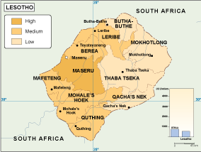
Available in multiple digital formats, this vector map of Lesotho's economy includes EPS and AI Illustrator files, ensuring full compatibility with various design software. With fully editable layers, you can customize elements to suit your project's needs, making it an essential tool for professionals in urban planning and economic analysis.
Upon purchase, you’ll enjoy instant delivery via WeTransfer and email, allowing for immediate access to the vector map of Lesotho. This seamless process ensures you can start your projects without delay, promoting efficiency and convenience.
Our vector map offers full reproduction rights, empowering clients in over 140 countries to utilize it for commercial and educational purposes. With this comprehensive resource, you can confidently represent Lesotho’s economic landscape in your work.