Italy land use
The vector map of Italy land use showcases the country’s diverse geography, located in Southern Europe, nestled between the Mediterranean Sea and the Adriatic Sea. Its coordinates are approximately 42°N latitude and 12°E longitude, featuring major cities like Rome, Milan, and Florence, along with significant rivers such as the Po and Arno. Italy shares borders with France, Switzerland, Austria, and Slovenia, making it a key point of cultural and economic exchange.
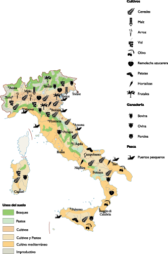
Available in digital vector formats such as EPS and AI Illustrator, the Italy land use map offers fully editable layers, allowing users to customize geographical features to suit specific projects. This flexibility makes it an invaluable tool for urban planners, researchers, and educators.
Upon purchase, customers can enjoy the convenience of instant download via WeTransfer and email, ensuring quick access to this essential resource.
Clients from over 140 countries benefit from full reproduction rights, enabling them to use the Italy land use vector map in various applications, from academic research to commercial projects. Get your hands on this comprehensive map today!