Chile mapa intercambio comercial
The vector map of 'Chile mapa intercambio comercial' offers a detailed overview of this South American nation, known for its long coastline along the Pacific Ocean. Located between the Andes mountains and the Pacific, Chile's coordinates are approximately 30°S latitude and 71°W longitude. Key geographical features include the capital city of Santiago, the picturesque Osorno River, and its extensive borders with Argentina, Bolivia, and Peru, which facilitate intricate commercial exchanges.
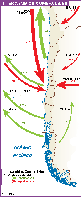
Available in digital vector formats like EPS and AI Illustrator, the map boasts fully editable layers, allowing users to customize it for specific needs. Whether you're a business professional or an educator, this versatile tool is perfect for visualizing Chile’s trade dynamics and geographical layout.
Upon purchase, enjoy instant delivery via WeTransfer or email, ensuring you receive your 'Chile mapa intercambio comercial' without delay. This seamless process makes it easy to integrate the map into your projects, presentations, or reports.
With full reproduction rights included, clients from over 140 countries benefit from this resource. This allows for extensive use in commercial and educational purposes, enhancing the map’s value and application in understanding Chile's commercial landscape.