Norway climate
Norway, located in Northern Europe on the Scandinavian Peninsula, is a country known for its stunning landscapes, including breathtaking fjords and expansive forests. It lies between latitudes 58°N and 71°N, bordered by Sweden to the east and the North Atlantic Ocean to the west. Key cities like Oslo, the capital, and important rivers such as the Glomma highlight its unique geography.
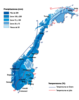
For designers and cartographers, the vector map of Norway's climate comes in versatile formats like digital EPS and AI Illustrator, ensuring seamless integration into creative projects. Each file contains fully editable layers, allowing for customization tailored to any thematic focus on climate data.
Upon purchasing, you can instantly download your vector map via WeTransfer or directly through email. This user-friendly delivery method ensures you have immediate access to your resources without delay.
Clients from over 140 countries enjoy full reproduction rights with their purchase, making this vector map an invaluable tool for educational, commercial, or personal use in exploring Norway's diverse climate.