Swaziland vegetation
The vector map of Swaziland vegetation showcases the unique geographical features of this landlocked country in Southern Africa, bordered by South Africa and Mozambique. Nestled between coordinates 26° and 31° South, the map highlights major cities like Mbabane and Manzini, as well as key rivers like the Great Usutu, making it an essential tool for ecological research and planning.
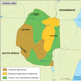
Designed for versatility, the map is available in digital vector formats such as EPS and AI Illustrator, featuring fully editable layers. This allows users to customize the vegetation details according to their specific needs, whether for academic purposes or professional presentations.
Upon purchase, customers can enjoy an instant download of the vector map via WeTransfer or email, ensuring immediate access to this valuable resource.
Clients receive full reproduction rights, making it easier to use the map in various projects. With satisfied users in over 140 countries, our product is recognized for its quality and reliability in the field of cartography.