Senegal climate
The vector map of Senegal climate prominently displays the country’s geographical features, including its strategic location on the west coast of Africa. Senegal is bordered by the Atlantic Ocean to the west and shares land borders with countries like Mauritania and Mali. Key points of interest include the bustling capital, Dakar, situated at the coordinates 14.6928° N, 17.4467° W, and the Senegal River, which serves as a vital source of water and commerce, enhancing the understanding of the nation's diverse climate zones.
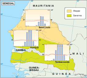
Available in digital vector formats such as EPS and AI Illustrator, this map offers fully editable layers for easy customization. Designers and researchers can effortlessly alter and adapt this vector map of Senegal climate to suit various projects, making it an invaluable resource for presentations and publications.
Delivery of the vector map is both convenient and efficient, with options for instant download via WeTransfer and email. This ensures that users receive their maps promptly and can start utilizing them without delay, perfect for urgent projects and collaborative efforts.
With full reproduction rights included, clients enjoy the freedom to use the vector map of Senegal climate without limitations. Trusted by users in over 140 countries, this resource is ideal for professionals looking to enhance their work with accurate and detailed climate representations.