Andorra economic
The vector map of Andorra economic highlights the country's unique geography nestled in the eastern Pyrenees mountains, bordered by France and Spain. This beautiful microstate boasts coordinates approximately 42.5° N latitude and 1.5° E longitude, featuring key points such as the capital city Andorra la Vella, the Gran Valira River, and its picturesque valleys that attract tourists and businesses alike.
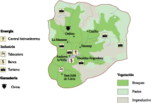
Available in versatile digital formats like vector EPS and AI Illustrator, this map comes with fully editable layers. This feature allows users to customize geographical details, ensuring that businesses and educators can tailor the information to suit their specific needs effectively.
Delivery is seamless, with instant download options via WeTransfer and email, enabling immediate access to this essential resource. This means you can quickly integrate the map into your projects and presentations without delay.
Clients in over 140 countries benefit from this vector map, as full reproduction rights are included. This ensures users can utilize the map for various purposes, establishing an affordable yet powerful tool for understanding Andorra's economic landscape.