Ivory coast physical
The vector map of Ivory Coast physical showcases this West African country located along the Gulf of Guinea. With coordinates approximately 8.5° N latitude and 5.5° W longitude, it features significant geographical elements such as Abidjan, one of the largest cities, the Comoé River, and borders with Ghana, Burkina Faso, and Guinea.
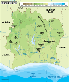
Available in digital formats like EPS and AI Illustrator, this vector map of Ivory Coast physical is fully editable, allowing users to customize layers and details as needed. Designed for versatility, it is ideal for various applications, including educational materials and professional presentations.
Upon purchase, you can enjoy instant delivery via WeTransfer or email, ensuring you have immediate access to the vector map of Ivory Coast physical.
With full reproduction rights included, clients from over 140 countries can confidently utilize this map for commercial or personal projects, making it a valuable asset for designers and businesses alike.